Ensuring new buildings can withstand liquefaction effects
Last updated: 27 July 2021

Changes from the November 2019 Building Code Update have revised B1/AS1 to ensure new buildings are built safe and strong enough to withstand liquefaction effects. This information assists authorities adapt to this requirement.
Background
In November 2019 a change was made to Acceptable Solution B1/AS1 preventing it from being used on liquefaction-prone ground. This change takes effect from 29 November 2021. The change was made as a result of the experience of the Canterbury earthquakes, and subsequent recommendations made by the Royal Commission of Inquiry.
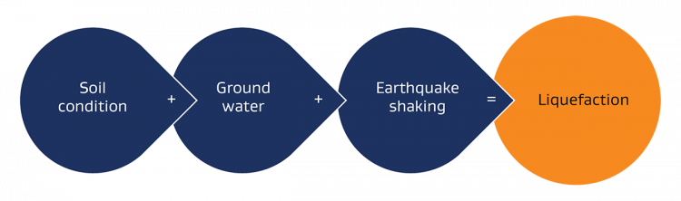
Figure 1: Soil liquefaction process
The change brings the rules that are currently in place in Canterbury to the rest of New Zealand, meaning robust foundations will be required for liquefaction-prone ground. The new rules will be mandatory across the country after 28 November 2021, ensuring new buildings are being built safely and strongly enough to withstand liquefaction risks.
This change will provide more clarity to local councils, Building Consent Authorities (BCAs), engineers and developers, resulting in safer and more resilient buildings.
Impact of 'Good Ground' definition change
The change to B1/AS1 helps those building on liquefaction-prone ground select foundations for residential homes. The change also revokes the use of a 'deemed to comply' pathway for foundations unless the ground has been assessed and/or categorised as not being liquefaction-prone – i.e. 'good ground'.
To ensure readiness for this change, councils have been advised to map their jurisdictions to undertake hazard mapping and identity liquefaction-prone areas. These regional hazard maps should be prepared using the Ministry of Business, Innovation and Employment (MBIE)/Ministry for the Environment (MfE) liquefaction mapping guidance to allow a smooth transition for this change coming into effect after 28 November 2021.
Changes to foundation design
To help identify suitable foundations for building work on sites subject to a liquefaction hazard, MBIE has developed the following resources to help councils, engineers and developers comply with this change.
- Flowcharts showing the pathways (and roadblocks) for those stepping through the building consenting process after 28 November 2021.
- Simplified method for specifying foundations for NZS 3604-type residential buildings.
- A summary for the assessment of liquefaction vulnerability at regional scale in accordance with the MBIE/MfE guidance (2017).
Regional liquefaction vulnerability assessment method-statement [PDF 15MB]
Learn more about the MBIE/MfE guidance 2017
This information is intended to help councils, BCAs, engineers and designers across New Zealand understand the 'good ground' definition change; to assist mapping liquefaction-prone-ground in their region; and to support the consistent design and specification of resilient foundations when the changes come into effect after 28 November 2021.
Designers must specify foundations to a level of resilience which reflects the importance of the structure and addresses the liquefaction hazard present. Defining the development scenario is the first step in this process. Higher importance building work will demand a higher level of rigour and confidence in the design process.
The methodology outlined is intended to inform the assessment of liquefaction hazard to support foundation design. It does not replace the need for site-specific geotechnical testing, review and interpretation by a suitably experienced engineering practitioner to establish the shallow ground conditions present and other hazards which may need to be addressed.
Regional liquefaction hazard maps
As part of the B1/AS1 update, local and regional authorities shall complete regional mapping of liquefaction hazard areas. These maps will typically be published in one of the following forms:
- maps that are prepared to capture knowledge and understanding of natural hazard processes in a particular area or location (hazard maps)
- maps that contain information about management responses or controls for a particular area or location (hazard management maps).
Hazard maps
Hazard maps capture broad information about hazards, reflecting the location (physical features) with a range of scenarios that show how natural hazard processes interact in that location. Those could include different types and severity of earthquake events. The purpose of these maps is to build understanding of the nature of the hazard and its potential physical impacts. These maps should be dynamic, frequently updated to reflect new information and test new or different scenarios. They should be a resource that can be used to help develop and test possible hazard management options and responses for a range of building types.
The MBIE/MfE 2017 Guidance anticipates that local and regional authorities will publish liquefaction hazard maps using a consistent methodology and hazard classification scale.
Hazard management maps
Hazard management maps capture location-specific information about proposed or agreed management responses. They can demonstrate where different policy frameworks or rules apply. Where these maps are included in District Plans, they have statutory status under the Resource Management Act (RMA) and can only be changed following formal plan change processes.
The Canterbury Residential Technical Categories (TC1, TC2 and TC3) are a hazard management map. They were intended to inform building work during a period of elevated seismicity following the 2010/2011 Canterbury earthquake sequence and published on a granular (i.e. property-specific) basis based on a combination of predicted and observed land performance They were also prepared to inform a particular type of building work - specifically one and two-storey timber-framed residential buildings.
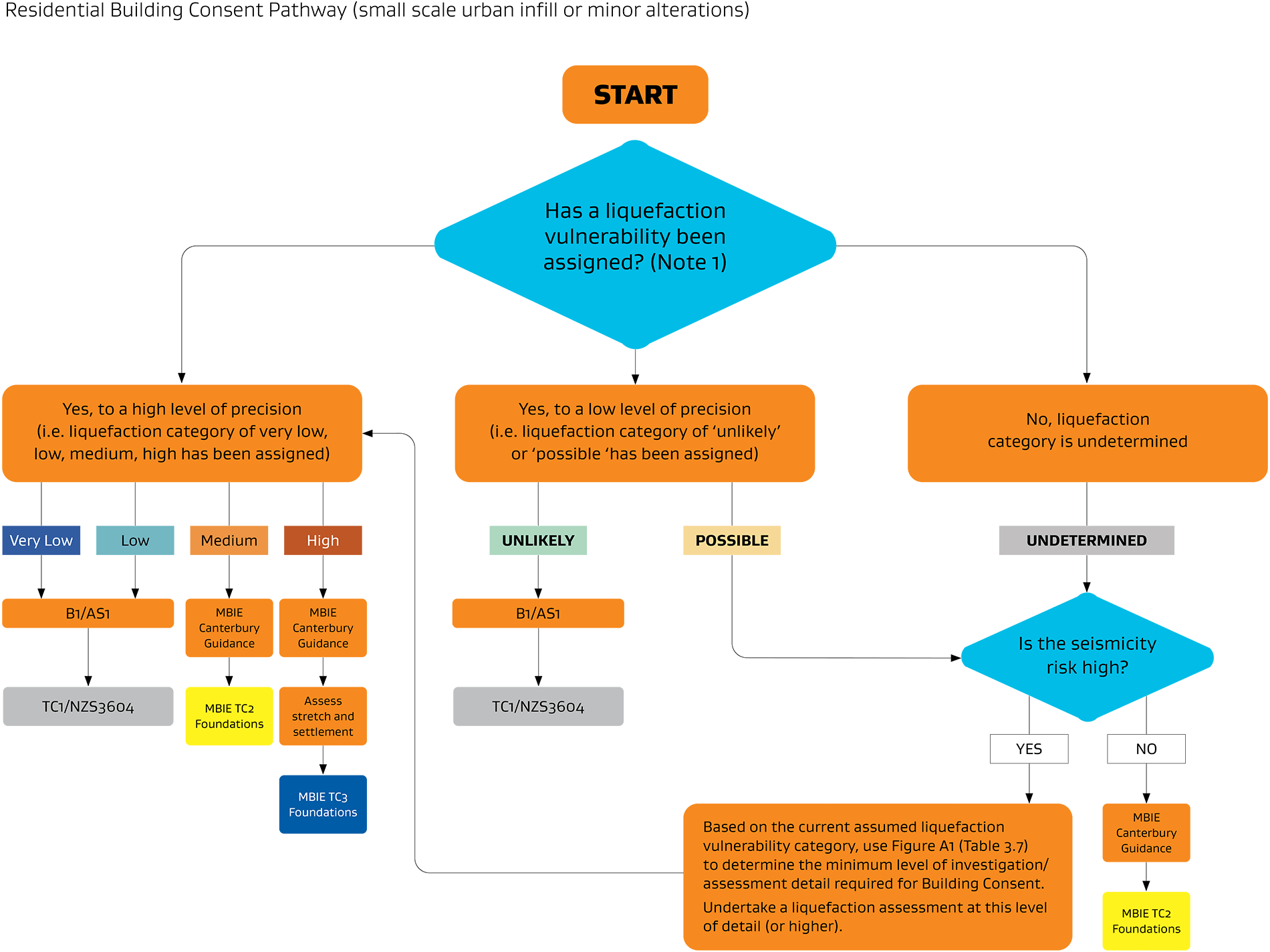
A desktop review of published liquefaction hazard information is an initial step in the design process. The designer shall determine the liquefaction vulnerability category which applies to the site and development scenario, with the input of additional site investigation and engineering input where required (Figure 2).
Consider seismicity risk
For most of New Zealand the changes to B1/AS1 are proactive rather than a response to observed damage following a recent earthquake or series of earthquakes. As a further step prior to engaging specialist engineering input, designers should review the regional seismicity to determine whether liquefaction is likely to be a governing consideration in foundation design.
Seismic actions and the relative contribution of performance criteria B1.3.1 (instability to collapse) versus B1.3.2 (loss of amenity) will vary with different types of buildings. For NZS3604-type residential structures on flat sites amenity is likely to be the governing consideration for the design and specification of foundations.
Figure 2: Overview of the recommended process to determine liquefaction vulnerability at building consent stage.

Table 1: Overview of the recommended process to determine liquefaction vulnerability at building consent stage.
| Step No. | What needs to be done? | How is it done? | Who does it apply for? |
|---|---|---|---|
| 1 | Define development scenario | Refer to Figure 3. Informed by Table 3.7 of the MBIE/MfE Guidance | BCAs, TAs, Engineers, Designers, Developers, Planners, Homeowners |
| 2 | Review of regional liquefaction hazard information and local seismicity. | Regional liquefaction hazard maps will be published by local and regional councils | |
| 3 | Determine whether liquefaction vulnerability has been adequately assessed. If not, undertake a liquefaction assessment. | Follow Figure 4 | |
| 4 | Complete geotechnical investigations to inform foundation design. | Scope of geotechnical investigation shall reflect the risk and complexity of the building work. Refer to accompanying notes for recommended minimum scope. | |
| 5 | Select foundations to comply with B1/AS1 | Follow Figure 5 (NZS3604-type residential building) |
Notes:
- As a minimum, MBIE recommends that geotechnical investigations be completed to establish shallow soil conditions, bearing capacity and groundwater depth. Section 2.4.4.1 of the NZGS/MBIE Module 2 Guidance "Geotechnical Investigations for Earthquake Engineering" outlines a minimum scope of shallow geotechnical investigation which is appropriate for NZS3604-type residential buildings.
- The scope of site investigation and geotechnical assessment should be tailored to the complexity and risk of the development proposal. Investigations should be completed prior to selecting foundations to ensure designs will meet the performance objectives of the Building Code.
- Site specific deep geotechnical testing and liquefaction analysis is likely to be required for high-risk sites within high seismicity areas.
- A shallow geotechnical investigation may be sufficient for simple building work in low-seismicity areas.
Figure 3: Defining the Development Scenario
 The various development scenarios have been separated into categories based on the level of capital investment and total exposure to a single event. The assessment levels are indicative only. Designers, Engineers and BCAs/TAs should apply discretion when undertaking geotechnical investigation and design review.
Note: Please refer to all the footnotes as prescribed under Table 3.7 on page 26 of MBIE/MfE Guidance.
View a full size version of Figure 3: Defining the Development Scenario
Figure 4: Defining Liquefaction Vulnerability
 The iterative process to provide a liquefaction vulnerability category is to continually refine the liquefaction assessment to the next higher level of detail until a vulnerability category can be confirmed with sufficient detail for the purpose of demonstrating compliance with the performance objectives of the building code.
It's important to note that the starting point of the categorisation does differ in some cases where high-level assessments may have already been carried out by a local authority.
View a full size version of Figure 4: Defining Liquefaction Vulnerability
Example - foundations for NZS 3604-type residential buildings
In New Zealand, B1/AS1 is widely cited as the means of compliance for residential building work, including foundations. The Amendment 19 changes to B1/AS1 which come into effect on 29 November 2021 revokes this compliance pathway for building foundations on sites where a liquefaction risk has been identified.
Liquefaction is a product of soil conditions, groundwater and earthquake intensity. Often a designer will lack information on one or more of these factors. Where this information is lacking, additional desktop review or site-specific geotechnical investigations can help inform designers about the remaining factors.
Experience from the 2010/2011 Canterbury Earthquakes has demonstrated that liquefaction induced damage can result in a loss of amenity to lightweight timber-clad residential buildings. This may include total or differential settlement which cannot be repaired on a cost-effective basis. This serviceability criteria is typically the governing requirement for residential building work rather than a risk of life-threatening structural collapse. For seismic design serviceability level actions are typically set at 25-30% of the peak ground accelerations expected at ultimate limit state.
As a simple compliance pathway, MBIE recommend designers consider the foundation options outlined in the Canterbury Guidance for the three technical categories as they relate to similar liquefaction vulnerability classes, i.e.
- Very Low and Low Liquefaction Vulnerability Technical Category 1 (TC1)
- Medium Liquefaction Vulnerability - Technical Category 2 (TC2)
- High Liquefaction Vulnerability Technical Category 3 (TC3)
It is to be noted here that:
- The above is not a direct correlation between the two sets as the vulnerability assessment is dependent on several factors.
- The designer or their representative should make reasonable inquiry to satisfy themselves that the mapped site vulnerability class is accurate.
- Geotechnical investigations and analysis should be targeted to inform design for the applicable development scenario.
- Designers should consider specifying more robust foundation solutions where ground performance is more uncertain.
Review of regional hazard information
A desktop review of published liquefaction hazard information is the next step in the design process for NZS 3604-type residential building work. To determine the level of geotechnical investigation needed and select a suitable foundation type from the MBIE Canterbury Guidance, the designer must first determine the liquefaction vulnerability category which applies. This is straightforward where the category has been previously assessed to a high level of precision.
Many New Zealand regions have only been mapped to a lower level of confidence than the Canterbury Guidance anticipates. Where land is mapped as 'liquefaction is possible' MBIE recommends that designers complete an additional step to review local area seismicity prior to commissioning further investigation and specialist engineering input.
Review of local seismicity and shallow ground conditions
Some parts of New Zealand are subject to greater levels of seismic risk than others. Experience from Canterbury has shown that shaking below a threshold is unlikely to result in surface manifestation of liquefaction.
Low Seismicity Regions
Where the local seismicity is low, and regional mapping has been completed to a low level of precision (i.e. 'liquefaction damage is possible', 'liquefaction damage is unlikely') and reasonable inquiry confirms that liquefaction risk is unlikely to exceed a 'medium' vulnerability class; MBIE recommends that foundation options outlined within Section 5.3.4 of the Canterbury Guidance be adopted (i.e. TC2 foundation options).
Reasonable inquiry is expected to include shallow investigations, as a minimum to establish the near surface ground conditions, bearing capacity and depth to groundwater. Section 2.4.4.1 of the NZGS/MBIE Module 2 Guidance "Geotechnical Investigations for Earthquake Engineering" outlines a minimum scope of shallow geotechnical investigation deemed broadly appropriate for NZS3604-type residential development.
Subject to project requirements, additional investigation and specialist geotechnical input may be appropriate to assess whether a more optimised foundation solution can be adopted.
High Seismicity Regions
A defining characteristic of high seismicity regions is the potential for liquefaction to be triggered under short return period earthquakes (i.e. serviceability limit state). A greater level of liquefaction assessment and specialist input is appropriate in high-seismicity regions.
Where a high seismicity region has been mapped only to a low level of precision, i.e. 'liquefaction damage is possible' MBIE recommends that specialist engineering input be engaged to quantify the hazard to a level of technical precision commensurate with Table 3.7 of the MfE/MBIE Liquefaction Planning Guidance.
Consideration should be given to staging geotechnical testing. It is possible that deep geotechnical testing to a 'Level B' or 'Level C' investigation density may be sufficient to determine the hazard to the required level of precision, particularly where these investigations conclude that a 'low' or 'medium' hazard class is applicable.
A 'Level D' investigation will be appropriate where 'high' liquefaction vulnerability is inferred or cannot be reasonably excluded based on area-wide hazard assessment. Site-specific geotechnical testing and professional engineering input will inform the vertical settlement and lateral stretch demands for foundation design on high hazard sites. Subject to appropriate design judgement, TC3 foundations outlined with the Canterbury Guidance may be suitable.
Figure 5: Selecting appropriate foundations
 Note: Geotechnical investigation and professional input will inform foundation design for sites subject to 'medium' and 'high' liquefaction potential.
Figure 5 shows how the liquefaction vulnerability classes can be used to select foundation options presented within the MBIE Canterbury Guidance (i.e. TC1, TC2 and TC3 foundations).
View a full size version of Figure 5: Selecting appropriate foundations
Resources
Existing guidance on addressing liquefaction includes:
- The Canterbury repair and rebuild guidance (commonly referred to residential guidance) provides technical solutions for working on Canterbury's earthquake-damaged houses.
Assessment, repair and rebuild of earthquake-affected residential buildings in Canterbury - Earthquake geotechnical engineering guidelines developed by MBIE and the New Zealand Geotechnical Society (NZGS) to improve engineering practice and increase the seismic performance of buildings and infrastructure.
Earthquake Geotechnical Engineering Practice Series - The Planning and engineering guidance for potentially liquefaction-prone land document covers the consistent planning approach making it easier for councils to prepare Resource Management Act policies and plans, and to process resource and building consent applications.
Planning and engineering guidance for potentially liquefaction-prone land